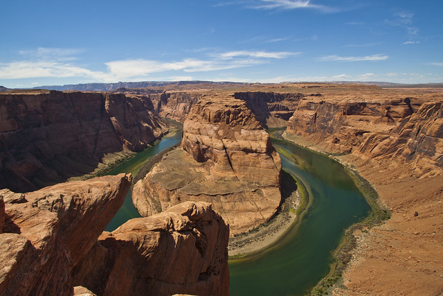
Horseshoe Bend is a horseshoe shaped bend in the Colorado River located in Page, Arizona, USA. Horseshoe Bend is one of the best and most scenic hikes in the lower region of Lake Powell. It is located 5 miles between Glen Canyon Dam and Lake Powell within GCNR (Gelen Canyon National Recreation) Area, just about 4 miles or 6.4km southwest of Page. The hike offers spectacular scenic views throughout your trip.
Tips to Hike Horseshoe Bend:
1. It is reachable only by hiking a 2.4km or 1.5mile round trip from Route 89 USA, but a service road also reaches this spectacular structure, but it belongs to the State Park. You can have an amazing view of Horseshoe Bend from the steep vertical cliffs above.
2. The hike begins with a climb up to the side of Sand dune and to the low mesa top. When you go to the peak of the mesa at west side, you can see the edge of Glen Canyon, below where you are actually looming into it, ahead of that you can see Vermilion Cliffs and Death Pockets.
3. The view is 1,300m or 4,200 feet above sea level and the River is at 980m or 3,200feet above sea level, which makes a 1,000 foot drop.
4. Remember, the trail goes only to the top of the canyon, but it is said that there is no way to reach down the river unless you have a parachute.
5. The trail has some edgy ups and downs, but it is said that it is easy, even if you aren’t in great shape, you can still make it if you climb in your own pace. But, don’t forget to click your camera, and don’t miss to capture the beautiful scenic sights during your trial.
Once you finish the trial, you’ll return to the trailhead through the same trial. You may feel like you are climbing up to reach the trailhead, don’t panic, you are climbing up to reach the end of the trail.
Remember the hike is not easy, you will get dehydrated and there is little shade and no water. Take lots of water and other necessary things with you and start early.
Photo Credit: Graeme Maclean